The Port of Prince Rupert is one of the busiest seaports in Canada, managed by the Prince Rupert Port Authority (PRPA).
As part of their commitment to sustainability and protecting marine life, PRPA engaged Ausenco in 2025 to create detailed georeferenced images (orthomosaic drone and sonar images), of the existing offsetting and habitat enhancements that have been created over decades by PRPA and their tenants as part of development projects.
This information will help assess habitat conditions, monitor cumulative effects, and support sustainable coastal development. The data will also establish a baseline for environmental conditions to help monitor and measure change going forward.
Using our extensive knowledge of the area and expertise in coastal habitats, our team deployed drones to obtain georeferenced imagery of the shoreline and intertidal habitat projects using various lenses and cameras to capture different perspectives and compositions. We used multispectral sensors to collect highly detailed visual maps of the canopy kelps, benthic algae, and marine substrates within the study area.
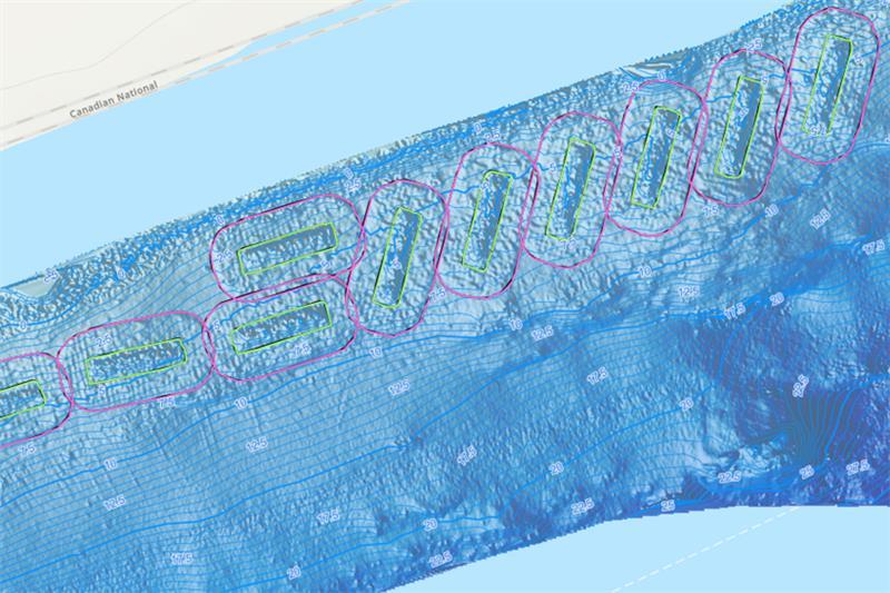
Concurrently, our subcontractor, Terra Remote Sensing, collected sidescan sonar and bathymetry data of subtidal offsetting habitats and the surrounding seafloor.
Our team was then able to utilise machine learning classification techniques and geospatial AI to help combine the two datasets, analyse the information, and classify different habitat types. With this approach, our team created highly accurate, detailed maps and 3D models of both terrestrial and marine habitats. The maps offered much greater spatial precision and temporal repeatability than traditional field-based methods.
In addition, our team created a client-ready dashboard that allows PRPA to interact with the maps. Individual buttons have been created for all habitat projects allowing users to zoom into each project area. Additionally, PRPA can turn on and off the different imagery layers including orthomosaic, design drawings, seafloor contours, bathymetry, and sonar images. We are now working with PRPA to further develop the portal into a comprehensive dashboard with additional layers, links, and access.
The challenge
Collection of field data required detailed planning to gather as much overlapping data as possible. This involved flying the drone at the lowest possible tides and conducting vessel-based sonar collection at the highest tides possible. This created overlap in the imagery which increased the overall sensitivity and detail of the mapping exercise.
Combining two differing types of data into one contiguous map and aligning images and point-cloud data to perfectly overlap was challenging. To meet this challenge, our team set protocols to facilitate effective communication between field personnel and individuals analysing the information during data collection. We also planned and invested the time needed to provide our staff with the necessary training.
Outcomes and achievements
Upon project completion, PRPA will have a comprehensive dataset that provides the baseline for environmental conditions around their port and surrounding areas. This information will form the basis of a cumulative effects monitoring platform that will help protect environmental conditions in the area and support sustainable development going forward.
This project successfully demonstrates how drone-based marine mapping and automated classification can enhance environmental assessment efficiency, improve data consistency, and support evidence-based decision-making in coastal management.